Plan Dealer Network Development - Quickly, Easily, Clearly
For manufacturers and distributors, an optimal dealer network is essential in order to reach as many customers and interested parties as possible. With the WebGIS software WIGeoWeb, you can handle all the planning steps of your dealer network development quickly, efficiently and successfully.
Professionally Manage Dealer Network Development with WebGIS
The WebGIS software WIGeoWeb supports you in dealer network development. This allows you to analyze your market using regional data and internal company data, find white spots, potential areas, define dealer areas and thus create the basis for necessary operational measures.
Your Benefits:
- Spatial analyses for you and your dealers
- Standardized reports on revenue figures and potential
- Transparent competition monitoring
- Clear representation on a digital map
All this allows you to create the conditions for customer-oriented sales through your dealer network.

Which industries does WIGeoWeb support in dealer network development?
Dealer network development primarily affects manufacturers and distributors of products requiring explanation in these sectors:
- Automotive
- Agricultural technology
- Medical technology
- Electrical engineering
- Mechanical engineering
The WebGIS WIGeoWeb also supports you in setting up and developing an optimal service network.
Do like the leading companies. Trust in WIGeoWeb, the WebGIS software!
How does WebGIS software support dealer network development?
The WebGIS WIGeoWeb provides you with answers to the following questions for dealer network development:
- Where are my potential areas?
- Where are white-spots where I should open new dealer locations?
- With which dealers am I already exploiting my potential?
- Where and how far away are my competitors?
- Where is my target group and where are the dealers who serve them?
The online tool WIGeoWeb displays all the relevant data, be it internal company data or demographics, on a digital map and provides you with the answers quickly, easily and clearly.

WIGeoWeb not only supports you in developing the dealer network, but also in providing individual advice to each dealer. With the information about the location environment, you can optimally support the dealer in achieving their goals.
Which data is important for dealers network development?
Sales success is inevitable when the choice of dealers and the distribution of the dealer network is not based on a gut feeling but on data analysis. Whatever data is included in the decision: As long as it has a spatial reference, the data is suitable for displaying and analyzing on a digital map in WIGeoWeb. In WebGIS, the relevant data is placed on top of each other in layers. This shows at a glance where there is a need for action in relation to the dealer network.
This data, among others, are crucial for dealer network development:
- Where do my existing customers live and work and how well are they already served?
- In which cities, regions, districts, ZIP Codes, neighborhoods, etc. can I find my target group (e.g. by age, purchasing power, lifestyle, etc.)?
- Where are there already dealers who are suitable for my products? And what potential do they have in terms of selling my products?
- Street data and traffic data: Which dealers can be reached easily by public or private transport?
- Company data: How well are which products already selling in which regions? Where are our A, B and C customers?
- Specific industry data
- Data on land use: Where is which area used and how?
All of this data and more can be obtained from WIGeoGIS and integrated into a WebGIS.
Try all the WIGeoWeb functions for free. Get your free trial access now!
How can manufacturers and dealers work together even better?
WIGeoWeb creates a decisive competitive advantage not only for the retailer search or retailer network development, but also for cooperation with your dealers.
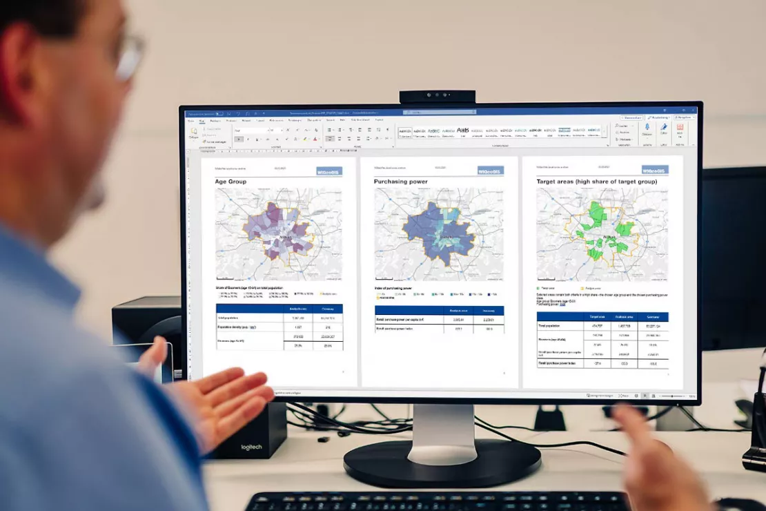
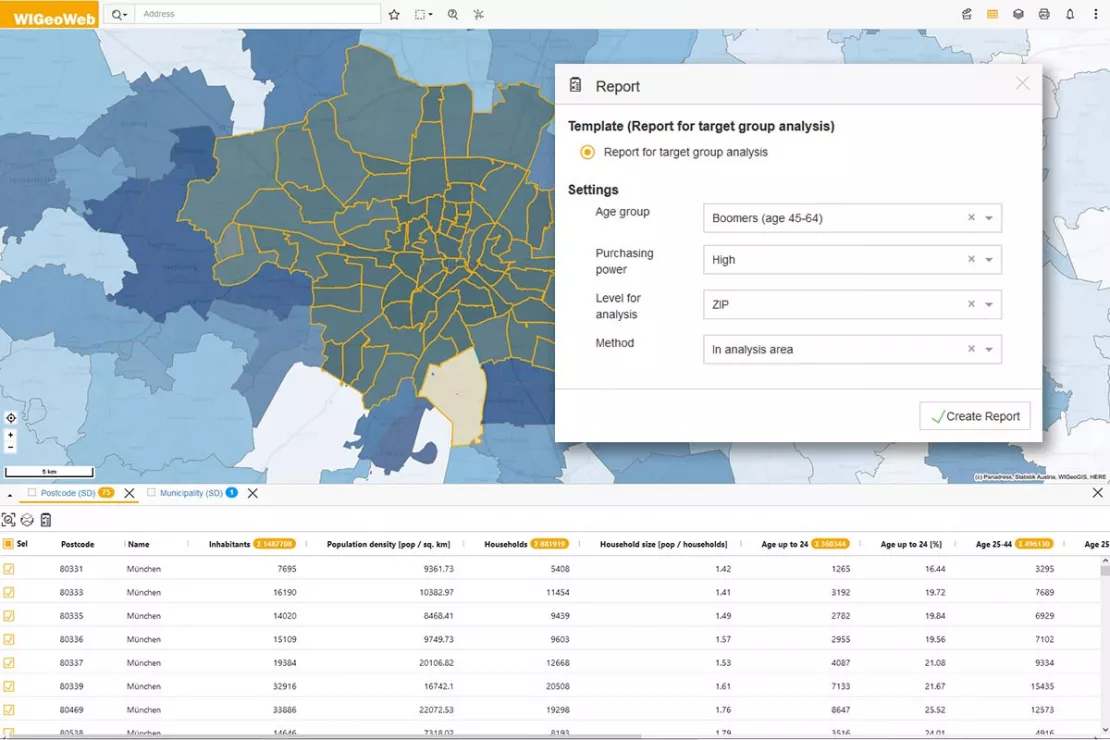
WIGeoWeb offers the opportunity to share tangible analysis results with retailers, for example by regularly and automatically creating and sending them reports. On this basis, goals can be agreed with dealers that are realistic and clearly understandable. All because the GIS software shows the potential for the products in question.
For example, data analysis with WIGeoWeb can show that a garden pool dealer can easily sell five pools per month. The manufacturer could then agree on a special bonus with the dealer for each additional pool sold.
What exactly the report should show can be set in advance. It is also possible, for example, to create separate reports for each product or region. Manufacturers can also advise their dealers on marketing and advertising measures based on the data analysis in the GIS (geoinformation system).

Data provides a valuable basis for decision-making. It does not matter whether it is socio-demographic data, land use data, infrastructure data, competition data or any other data. In conjunction with your company's own data, you receive information for your daily work. You can query your individual reports in WIGeoWeb.
Which GIS analyses help with dealer network development?
With geographic information systems such as WIGeoWeb, various types of data analyses can be carried out:
- With a white-spot-analysis you can find the best regions for expanding your dealer network by quickly identifying the white spots for your business on a map
- Scoring models allow you to compare the potential of your dealer locations with one another or see the potential for planned locations at a glance
- With a gravity analysis you can find out how attractive existing or planned dealer locations are
- A location-allocation-analysis can help you achieve the optimal location-customer allocation for your dealer network
- With the help of a cannibalization analysis, you can see at a glance on a map where dealers are too close to each other and are stealing sales from each other
Test WIGeoWeb for 30 days, free with no obligation. The trial period ends automatically.
9 Benefits of GIS Software for Your Dealer Network Development
Data analysis with the GIS software from WIGeoGIS will help you to
- Continuously adapt your dealer network to your requirements, for example after introducing new products
- Reach new target groups
- Support your specialist dealers in advertising planning and investment decisions
- Perform market analyses and potential analyses
- Optimize your Territory Management
- Automatically update international address databases and territory data
- Send automatic reports to your dealers
- Better compare your dealers with each other
- Organize sales and customer service professionally
Would you like to test a WebGIS? Request your WIGeoWeb test account for free with no obligation.
These Companies Rely on WIGeoWeb for Their Dealer Network Development

Case Study STIHL
The manufacturer of chainsaws and tools for the construction industry and gardening and landscape maintenance uses the location analysis software WIGeoLocation for the development of its retail network and advertising material planning.

Case Study WebGIS: This is how CLAAS uses WIGeoWeb
Potential analysis, market analysis and territory management all with one WebGIS! Yes! CLAAS has been using its own WIGeoGIS WebGIS to answer many questions since 2014.

Sales Area Planning at Ascendum Construction Equipment
Ascendum sells, rents and services premium quality construction equipment. In six countries, Ascendum plans sales, customer service and recruitment with geomarketing software.
Retailer Network Development using WebGIS: Request a free initial consultation
- FREE initial consultation on Retailer Network Development
- Non-binding, without further obligations
- By telephone or video call
Do you want to know more about Retailer Network Development? I will gladly support you. Please contact me!
* The products of WIGeoGIS are intended for companies and are not suitable for private use. If you need a one-time market analysis, we will gladly make you a service offer.
FAQ
-
What are the basics of successful retailer network development?
The basics of successful retailer network development are made up of several aspects: It is about a realistic assessment of
- Your market potential
- Your existing competition
- And establishing your retailer network
With the help of a WebGIS system such as WIGeoWeb, you can visualize and analyze the relevant data, including both company data and market data, on a digital map.
-
How does the WebGIS WIGeoWeb support manufacturers, distributors and their retailers?
WIGeoWeb supports manufacturers and distributors to establish an optimal sales network and/or service network. In addition, retailers are provided with regional market data and potential analyses to provide them with the best possible overview of their market opportunities.
-
How can market volumes and market potential be broken down to individual retailers?
With WebGIS-Software, market volumes and market potential can be easily broken down into individual retailers through the process of disaggregation. Josef Mayer, Head of Solutions at WIGeoGIS, explains: “A disaggregation is usually done when data in finer granularity is either not available across the board or is very expensive.”
Disaggregation may be necessary, for example, to agree upon realistic sales targets with retailers. For example, if I know the total market volume of a product and how many households that are in the target group for that product live in a retailer's catchment area, I can calculate that retailer's market potential using disaggregation.
Conversely, data can also be aggregated, for example, the sales of all retailers in a federal state.
-
What are white spots in retailer network development?
White spots in retailer network development are regions where I do not yet have any, or not enough retailers or operating partners, but where there is potential for my product. In order to make the best possible use of the existing potential, it makes sense to look for or place retailers exactly there. With the help of a white-spot-analysis, you can identify the white spots for your own business.
-
Are gravity analyses relevant to retailer network development?
Gravity analyses are used in spatial analytics for sales forecasts, whereby attractiveness, accessibility and the competition are included in the analysis. For this reason, gravity analyses are very useful when developing retailer networks or restructuring sales territories.
-
Can I develop a global retailer network with WIGeoWeb?
Yes, global retailer networks can be optimally developed with WIGeoWeb. Data, including both external data, i.e. market data, and internal data, i.e. company data, form the basis for a global retailer network development. This data can be integrated into the WebGIS software.
You have the option of proceeding country by country and can also make certain data and functions of the software available to your national organizational units using a role and rights concept. This gives you a central system for all your markets and allows you to compare them clearly and easily.
-
How does geomarketing help you with retailer development?
Geomarketing supports you in retailer development by making the results of your analyses available to your retailers. This is easy to do in WebGIS software like WIGeoWeb using reports that are automatically created and distributed. These reports can serve as a basis for your retailers for regional sales and marketing measures, as each retailer receives a transparent overview of their area through this reporting. And your company receives valid information about the market utilization of the individual retailer areas.

