Real(e)value uses WebGIS in real estate appraisal
“WIGeoWeb is browser-based like our core product and meets the flexibility requirements we need to connect our IT solutions and optimize our process workflow.”, Jürgen Luhn, Managing Director Real(e)value

Case Study Overview
Customer: Real(e)value
Application: Real estate appraisal
Product: WIGeoWeb
Goal: Comprehensive evaluation of real estate by adding relevant parameters of the catchment area
Use: Real estate professionals (banks, insurance companies, real estate agents, authorities, etc.)
Real(e)value extends its proven real estate appraisal system with a spatial representation tool
With their LIEBE system, the real estate appraisal service provider has been offering a high-performance product for years. By spatially analyzing the data with WIGeoWeb, relationships are now recognizable at a glance and the appraisal becomes even more accurate and valid.
Imagine that you have a house, apartment or land for sale and need a reliable estimate of the market value of your property. Would not it be practical if you could simply enter the key data on the location, size, age and condition of the object into an online tool and immediately received a sound and objective appraisal?
Real(e)value developed just such a tool and it has been successfully used throughout Austria since 2008. The companys target group includes banks, insurance companies, real estate agents and public authorities, in other words users who appraise real estate professionally. Since Real(e)value was founded, WIGeoGIS has been supporting them with software and data.
Purchase Price Benchmarking
The tool, which has the sweet-sounding name “LIEBE”, for Liegenschaftsbewertung, (LOVE - property valuation), achieves an accuracy of single digit percentage deviations from the future purchase price. This is made possible by the use of high-quality data and powerful mathematical models, that are scientifically recognized and are constantly reviewed by the Vienna University of Technology. The appraisals are based on the extensive in-house data sets collected by Real(e)value in previous appraisals, supplemented by available geo and sociodemographic data from third-party providers on population, purchasing power, topography, etc. One of the strengths of the tool is that the appraisal is not based on real estate broker offers, but on actual realized purchase prices.
Comprehensive support for experts
In order to provide real estate experts comprehensive support in the individual process steps of their appraisal, Real(e)value has created an entire set of tools to supplement the core product. For example, a walk-through app facilitates on-site inspections. The individual tools are technically integrated and connected in a user-friendly manner through suitable interfaces.
“Until now, we could only export the data as a list or table, which is too abstract in practice. Only with the help of spatial representation can we quickly draw the right conclusions.”
Jürgen Luhn, Managing Director Real(e)value
Quantum Leap through Spatial Representation
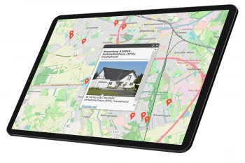
The most recent tool in this kit is a browser-based visualization tool that finds comparison objects in the surrounding area and presents them graphically on a map. The tool was realized with WIGeoWeb, the flexible WebGIS software from WIGeoGIS.
Jürgen Luhn, Managing Director of Real(e)value, explains a classic use case: “An appraiser has used the LIEBE tool to appraise the value of a five-year-old, 90 m2 condominium. With WIGeoWeb the appraiser can now view apartments of comparable size and age that were sold in the vicinity of the object.The exact catchment area can be drawn as a polygon on the map using the mouse.”
The apartments found, together with their corresponding values and key figures, are displayed directly on a map in the browser. A report is generated and an average is calculated. If it diverges significantly from the previously determined market value, the appraiser is required to correct it based on their experience and competence.“The expert can focus on their core competence, namely the review and confirmation or correction of the suggested value. Until now, we could only export the data as a list or table, which is too abstract in practice. Only with the help of spatial representation can we quickly draw the right conclusions”, said Luhn. For example, if an object is located very close to the apartment, but it is in a completely different district, this can be seen at a glance on the map.“That object would distort the purchase price and can be removed by the appraiser from the estimate. With the WIGeoWeb analysis, the expert can ensure the accuracy of their appraisal based on the LIEBE tool.”
Making Relationships Visible Spatially. Individual, flexible and efficient with our WebGIS solutions.
“The system learns with each appraisal and thanks to the spatial combination of the data it provides analyses in a form unlike any other database in the world until now”, says Norbert Hackner-Jaklin, Key Account Manager at WIGeoGIS. “It clearly shows how with the help of WIGeoWeb we can make complex, unstructured data readable. We are not making a WebGIS for the real estate industry, as that would not be effective. Our software draws its strength and individuality from the respective customer data and can be applied across every industry.”
Easy to Use
The tool was rolled out in the first half of 2018. CEO Jürgen Luhn is satisfied with the progress of the project: “We have come to know WIGeoGIS over the past ten years as a reliable and competent partner. The combination of data provider and service provider is optimal for us. WIGeoWeb is browser-based like our LIEBE tool and meets exactly the flexibility requirements we need to connect our IT solutions with each other and to optimize our process workflow. We were also won over by the easy to use interface which is perfect for our wide circle of users.”
WIGeoWeb for Real(e)value Tutorial-Video:
“The system shows how with the help of WIGeoWeb we can make complex, unstructured data readable. It learns with each appraisal and thanks to the spatial combination of the data it provides analyses in a form unlike any other database in the world until now.”
Norbert Hackner-Jaklin, Key Account Manager at WIGeoGIS
Real estate industry - further case studies and information

Case Study Archdiocesan Ordinariate
Daycare centers, churches, parish homes - the Archdiocesan Ordinariate of Munich and Freising uses modern GIS tools from WIGeoGIS when planning the needs for the building infrastructure.

Finding Exact Geocoordinates: Real Estate Valuation at vdpResearch
vdpResearch creates over 600,000 valuations annually. They are based on coordinates provided by the JoinAddress geocoder.

ANWR GROUP Manages Real Estate Offers with WIGeoLocation
Location offers are managed centrally with a WebGIS extension. This increases the efficiency and speed in the market.

WIGeoGIS supports Colliers International Poland
Comprehensive real estate valuation with GIS technology, new models of real estate valuation that are supported by GIS systems and geodata.
WIGeoWeb: Fill out the form, test it free of charge & without obligation!
- Non-binding, free test for 30 days
- Test ends automatically without cancellation
- An employee will explain the tool in a short webinar*
* Information about the free test access: Standard regions with selected data in Germany or Austria will be made available. In Germany, these regions are districts in Munich and environs, and districts of Vienna and environs in Austria. The products of WIGeoGIS are intended for companies and are not suitable for private use. If you need a one-time market analysis, we will gladly make you a service offer.

