Austrian Post: Branch Network Planning & Parcel Delivery
The “where” plays a major role for Austrian Post: Where are branches, parcel shops, and self-service stations needed? Where do customers pick up their packages? These questions are answered using the WIGeoWeb software and geodata from WIGeoGIS.

Case Study Overview
Customer: Austrian Post
Areas of application: Branch network planning, parcel pickup notice planning/parcel delivery
Product: WIGeoWeb, proprietary tool BenTo (based on WIGeoWeb)
Goal: Optimal distribution of branches in compliance with the requirements of the Postal Market Act, ideal allocation of parcel collection
Use: Approximately 50 users in the Austrian Post Geocompetence Center and delivery organization
Austrian Post: A Postal, Logistics, and Service Group in Transition
Austrian Post is an international postal, logistics and services group. Austrian Post has three operating divisions: Mail & Direct Marketing, Parcel & Logistics, Branch Network & Banking. The core business includes, among other things, the delivery of traditional letters, advertising mail, parcels, and express shipments.
The publicly listed Austrian Post is headquartered in Vienna and has subsidiaries in twelve other countries.
The postal market is undergoing significant change. Following the international trend, the letter mail volume of Austrian Post declined from around one billion items in 2009 to just over 500 million in 2024. In contrast, the parcel market grew strongly over the same period: from 50 million parcels in 2009 to 220 million in 2024.
Do like the leading companies. Trust in WIGeoWeb, the WebGIS software!
How WIGeoWeb Helps Austrian Post Optimize Branch and Parcel Station Planning
The question of “Where?” is more critical to Austrian Post than almost any other company. After all, addresses are part of the core business of Austrian Post when it comes to delivering letters or parcels.
In addition, there are two other areas where Austrian Post needs answers to the question of “Where?”:
- Branch network planning: The Postal Market Act stipulates that all Austrians must have access to a nearby post office or postal partner. No one should have to travel unreasonable distances to retrieve their parcel.
- Parcel pickup/parcel pickup notice: Anyone who receives a parcel and is not at home when it is delivered will receive a parcel pickup notice. This notice indicates where the parcel can be collected.
In both cases, Austrian Post uses the geomarketing software WIGeoWeb: on the one hand, to find the right post office branches and locations, and on the other, to determine the pickup location for parcels, be it a branch, a post office partner, or a self-service station.

How Austrian Post uses WIGeoWeb for branch network planning
Austrian Post operates branches and locations throughout Austria, ensuring that the Austrian population has reliable access to postal services nationwide. However, it is not up to Austrian Post how far their branches can be from the residents; that is stipulated in the Postal Market Act.
“Since we have to comply with the legal requirements of the Postal Market Act regarding the distance between branch locations and postal partners, we have to plan our branch locations based on different criteria than many retailers. Unlike food retailers, for example, we are not dependent on high-frequency locations.”
Simone Seemann-Ortner, Head of the Geo & Address Services at Austrian Post
What data is incorporated into the Austrian Post branch network planning?
Package Delivery
For supermarket chains and many other retailers, expected foot traffic from their target group is a crucial factor in choosing a location. For Austrian Post, however, such criteria play only a minor role in location planning. More important, for example, is that access to the branch is guaranteed for parcel delivery without obstructing traffic.
In addition to the legal requirements, further criteria for branch network planning, postal partner locations and self-service stations include:
- Demographic data such as population in the catchment area
- Distances and times required by residents in the catchment area to reach the branch, post office partner, or self-service station
- Information on opening hours (to realistically depict the attractiveness of post office locations)
- Visitor frequency and comparative experience from other Austrian Post locations
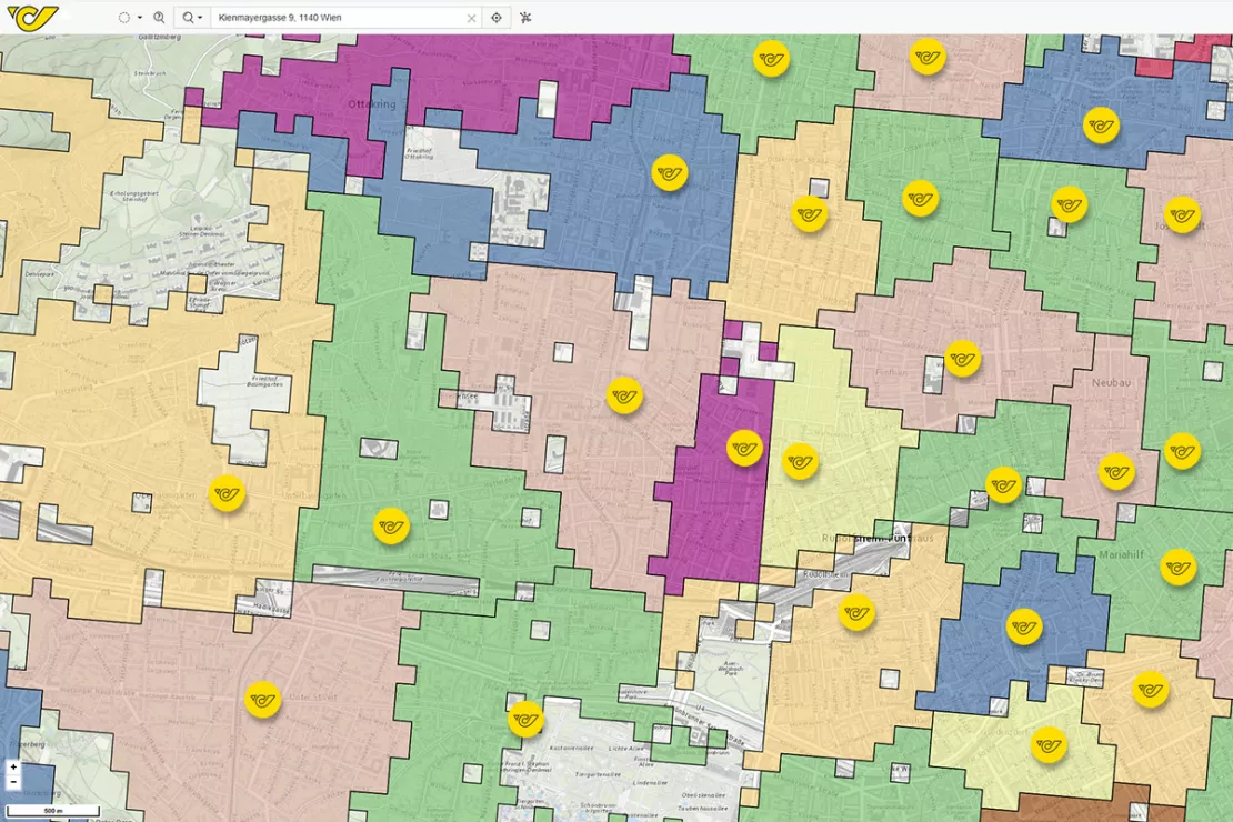
This and further information are graphically presented and spatially analyzed on the virtual map in WIGeoWeb. Potential locations can be evaluated for their suitability as a high-traffic Austrian Post location.
Test WIGeoWeb for 30 days, free with no obligation. The trial period ends automatically.
How does Austrian Post use WIGeoWeb to plan branch locations?
To find the best locations, WIGeoWeb performs automated calculations in the background and incorporates proven geomarketing methods. Among others, these include:
- Gravity analysis and the underlying Huff model: This calculates how many people are likely to visit a post office at a specific location. It can also be used to calculate how customer flows would change if a branch were relocated from one location to another. Gravity analysis measures the attractiveness of a location, in other words the likelihood that customers will visit it from their home or workplace.
- the Greenfield analysis, a subcategory of white spot analysis: Here, location planning is carried out virtually “on a blank slate”. In other words, it assumes there are no existing locations. The GIS software uses data to determine where the best white spots would be if you were planning your branch network or locations completely from scratch.

How geomarketing supports Austrian Post in planning parcel pickup
Anyone not at home when a parcel is delivered receives a parcel pickup notice from Austrian Post. It states where and when the parcel can be collected, for example, at a nearby post office, a postal partner, or a self-service station.
But how do you choose the right pickup location? A number of factors and data influence this decision, including:
- the distance between the original delivery location (e.g., the home of the recipient) and the pickup location
- the current capacity of the branches or self-service locations
The postal carrier has to quickly decide which pickup location is best for the recipient, and this is where the BenTo application comes in, powered by the geomarketing software WIGeoWeb. This provides the base data for an app that runs on the handheld devices of the postal carriers. This app ensures that the postal carrier knows where to take the package immediately after an unsuccessful delivery attempt. The parcel pickup notice containing the information is promptly printed and left in the recipient's mailbox.
Test WIGeoWeb for free. The WebGIS software is fully functional.
Other areas where Austrian Post uses WIGeoWeb
In addition to branch network planning, Austrian Post also uses WIGeoWeb for distribution planning of advertising mailings. Advertising mailings such as brochures from grocery retailers or information and advertising leaflets from smaller businesses like restaurants, which many Austrian households regularly find in their mailboxes, are also planned with geomarketing software from WIGeoGIS. This is how advertising reaches the right target audience.
Read about our second use case for Austrian Post here.

Further Information about WIGeoWeb and Customers Who Rely on WIGeoGIS Software:

WIGeoWeb: WebGIS for Geomarketing
WIGeoWeb is your online GIS for business analysis. Interactive maps. Visualize data. Simple. Intuitive. The WebGIS for your company.

Viterma Bathroom Renovation: Sales Territory Planning to Franchise Consulting
Sales forecasts, sales territory planning, franchise consulting: Viterma uses the WIGeoWeb software in a variety of ways across the DACH region.

Strategic Retailer Network Planning – Example hagebau
WIGeoLocation, the geo and location analysis tool, provides support for real estate valuation, location development and sales area optimization

Case Study: Lotto Baden-Württemberg
Lotto Baden-Württemberg relies on the geo tool WIGeoLocation and data from WIGeoGIS for location analyses and location planning. This allows the betting provider to successfully further develop its network of locations.
WIGeoWeb: Fill out the form, test it free of charge & without obligation!
- Non-binding, free test for 30 days
- Test ends automatically without cancellation
- An employee will explain the tool in a short webinar*
* Information about the free test access: Standard regions with selected data in Germany or Austria will be made available. In Germany, these regions are districts in Munich and environs, and districts of Vienna and environs in Austria. The products of WIGeoGIS are intended for companies and are not suitable for private use. If you need a one-time market analysis, we will gladly make you a service offer.
Copyright Images: Austrian Post, WIGeoGIS GmbH
Would you like to test a WebGIS? Request your WIGeoWeb test account for free with no obligation.

