The Lensing-Wolff media company uses geomarketing
Minimum wage has put the newspaper sector under pressure since 2015. Publishing houses must expect additional costs of around one billion Euro over the next five years. The Lensing-Wolff media company implemented a customised GIS by WIGeoGIS to manage this economic challenge.

Case Study Overview
Customer: Lensing-Wolff media company
Application: Newspaper delivery
Product: Custom Desktop-GIS
Goal: Optimization of the delivery process and planning through appropriate distribution of districts, ideal routes and accurate and fast calculations
Use: Geoinformation systems Sales service department
Geomarketing - this is how the Lensing-Wolff media company has the minimum wage challenge under control
The problem: Minimum wage is forcing the sector towards a cultural change. It must change from piece wage to hourly. Publishing houses cannot remain economical under these circumstances unless they create ideal regional structures and delivery processes. The Lensing-Wolff media company is streets ahead of others in the sector – it has implemented this using a customised GIS.
Delivery of newspapers poses a logistic challenge – more so in times of minimum wage. Publishing houses are now no longer paying their delivery agents for the number of distributed newspapers, but for their time. Publishing houses, however, don’t know the time it takes for the deliveries. They therefore also don’t know whether they are paying their carriers the minimum wage. Publishing houses must determine the delivery times. One option is to ask the carrier. A second option: Use a geomarketing tool to simulate the routes of the carriers as realistically as possible and then calculate the hourly wage.
Lensing-Wolff opted for the latter and now uses ArcGIS extensions programmed for the media company. “No publishing house can these days afford logistics which are not transparent or inefficient. The sector is under financial pressure. To work economically, you need optimal delivery processes," asserts Torsten Schmechel. Schmechel is head of the Geoinformation systems Sales service department at Lensing-Wolff, where he developed the GIS Department. The focus is currently on the implementation of the minimum wage. The minimum wage must not turn into an operational burden. Process optimisation is the order of the day.

Savings potential through new regional structures
Analyses of regional structures is the sine qua non for any optimisation. “The
analysis showed that many regions were demarcated ineffectively.
Carriers were walking unnecessary because routes overlapped. By simply
more logical demarcation of regions, we managed to reduce delivery times
and thereby increase delivery quality,” says Schmechel. The so-called walking lines – meaning the exact path taken by a carrier - are specific to each region.
Ideal walking lines for carriers
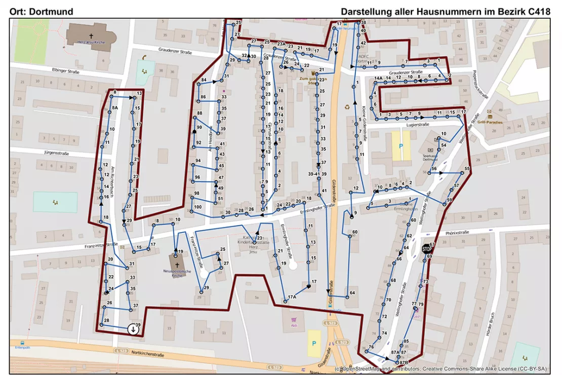
“We need a map with detail down to house numbers. Road maps are
not enough. We need to know the exact distance from walking line to
front door, in metres. We absolutely need this to determine ideal
walking lines and exact times,” explains Schmechel. The minimum wage
tool will calculate the working time of the carrier per day of
delivery. This requires: Address points, walking lines depending on the
means of travel and time to a post-box. Every carrier may download his
ideal route and the sequence of calling at the associated subscribers.
The GIS simultaneously generates such maps for hundreds of regions. “This previously had to be done manually for each region, requiring several days. It requires only 10 minutes these days,” says the GIS expert.
Lensing-Wolff has been relying on GIS for seven years now
With this approach, the media company has become a pioneer in its sector. Says Schmechel: “Using
the GIS and such methods, we were in a position to depict and analyse
night-time delivery processes ever since. This has given us a head start
in terms of the minimum wage issue. Many publishing houses have only
recently examined the benefits of GIS as a solution to this challenge.”
Industry insiders also know: “Many publishing houses rely on
preconfigured systems. Publishing houses, however, need a tool capable
of addressing a company’s specific requirements. This is why we need
WIGeoGIS, offering us practical tools to satisfy our requirements.”
Media planning - further case studies and information

Expansion planning at dm-drogerie markt
Location decisions are among the most important and long-term tasks in the development of a commercial enterprise.

CROSSMEDIA - Precisely target your target audience
Media campaign can be optimally planned both spatially and to a given target group.
GIS Software: Request a FREE Live Demo!
- FREE Live-Demo* of GIS Software
- Non-binding, without further obligations
- Online presentation via video call
Do you want to know more about GIS software? I will be glad to support you.

