Branch Marketing with Geomarketing
This is how Erste Bank Austria Optimally Manages Branch Advertising

Case Study Overview
Customer: Erste Bank Austria
Application: Location-based marketing of branches
Product: WIGeoLocation plus custom-developed extension, Geocoder JoinAddress
Goal: Effective marketing measures in the catchment area of the bank locations, simplified customer management
Use: Branch marketing for more than 130 locations
Erste Bank Austria uses geomarketing to optimally manage branch advertising
Today, banks must focus more than ever on the needs of the customer. In terms of marketing activities, this means that banks should distribute advertising in such a way that it reaches the relevant target group as precisely as possible. The branch marketing of Erste Bank Austria already implements this approach in many areas with the help of geomarketing.
With the help of geographic analyses, they are able to plan efficient and personalized measures for each of their more than 130 branches. The geomarketing software that makes this possible comes from WIGeoGIS.
Increasing competitive pressure and decreasing customer loyalty are forcing banks in Germany to rethink their approach. One of the challenges for banks in general is that they need to focus more on customers and better align their service quality with customer expectations. This was the finding of the Lünendok Trend Study on the Future of Banks 2020. Ulrike Hofmann knows this well and has therefore relied on target group-oriented advertising campaigns for many years now. She is Head of Branch Marketing at Erste Bank Austria. Erste Bank acts as the lead institution of the Austrian savings banks.
Ulrike Hofmann interprets even more service quality and the fulfillment of customer expectations as follows: “Many companies flood their customers with advertising. We do not want to do that. My department is responsible for individual branch campaigns and it is very important to me to adapt to regional circumstances. We distribute our information in such a way that it is as relevant as possible for the addressees or customers and potential new customers. Irrelevant advertising does not receive any attention and, in the worst case, may actually be an annoyance.”
Geomarketing Makes It Possible to Optimally Align the Branch Marketing Activities
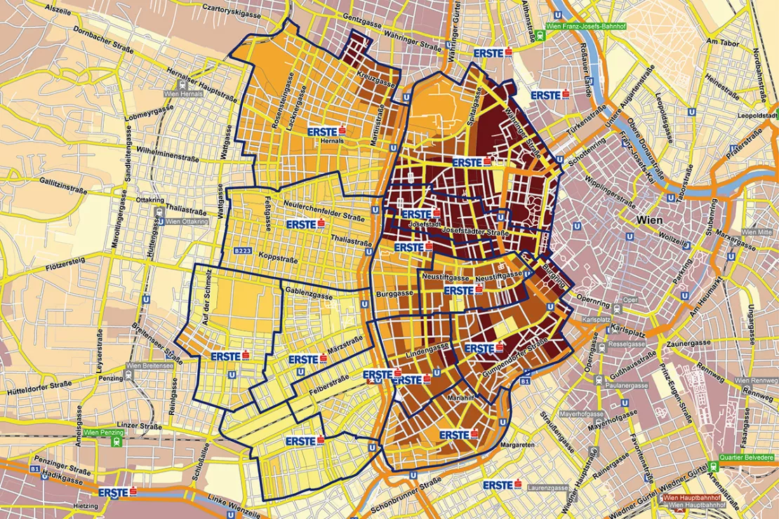
The first and most important step is a detailed catchment area analysis of the respective branch. The branch marketing at Erste Bank conducts such analyses with the help of branch-based geomarketing software from WIGeoGIS.
Interested in WebGIS: Test WIGeoLocation free of charge and without obligation
Efficient and Effective Distribution of Household Advertising per Bank Branch
Ulrike Hofmann and her six-member team analyze the catchment areas of the various branches with regard to the target groups. This makes an optimal regional distribution possible. “With the geomarketing analyses, we know exactly where in a branch office’s catchment area concrete activities make sense, for example, for our current account, the most modern account in Austria. Here in the catchment area, we have selected the districts with the lowest percentage of customers that are located near the branch office. The target group specific alignment allows us to increase the relevance of the advertising mail and thus the effectiveness. We receive this feedback regularly from the branch offices,” says Ulrike Hofmann. Such spatial and content selection is only possible with geomarketing.
Optimal Location for Promotion Campaigns and Finding Regional Cooperation Partners
Erste Bank uses geomarketing analyses for more than just household advertising. “It is important for our branches to know where potential cooperation partners are located. In the case of spark7, the youth brand from Erste Bank, we use geographical analyses to search for places that are particularly frequented by young people. These include, for example, beauty stores or clothing stores that are particularly popular with young people,” says Hofmann. In addition, the geomarketing software helps you select the optimal locations for promotional activities.
Automated Assignment of Addresses from Advertising Campaigns to Branch Offices
The addresses of new customers are often kept in lists. “We can upload such Excel address lists to the WIGeoGIS tool. The program then automatically geocodes the data. The tool assigns each address to the branch office with the matching the catchment area. In the past, we had to assign the addresses manually, which was extremely time-consuming,” explains Ulrike Hofmann.

Addresses from advertising campaigns and sweepstakes can also be optimally evaluated through geographic analyses, says Kai Barenscher, Senior Consultant at WIGeoGIS: “The geomarketing analyses show regional abnormalities in response behavior. Companies know in which regions and areas there was a lot or little return. This evaluation is not only helpful for checking the success of an advertising campaign. It also allows you to draw conclusions about regional preferences and interests. This allows banks and other companies to get to know their target group better.“
Geomarketing helps in many ways to make the branch
marketing for banks more targeted and efficient. It is not good enough
to rely on your gut feeling for regional marketing campaigns. They need
to align advertising with customer expectations requires a much more
sophisticated approach. Geomarketing is a possible way to achieve better
accuracy and effectiveness in branch marketing.
"Many companies flood their customers with advertising. We do not want to do that. My department is responsible for individual branch campaigns and it is very important to me to adapt to regional circumstances. We distribute our information in such a way that it is as relevant as possible for the addressees or customers and potential new customers. Irrelevant advertising does not receive any attention and, in the worst case, may actually be an annoyance."
Ulrike Hofmann, Head of Branch Marketing ERSTE Bank AG
Location analysis - further case studies and information

Case Study STIHL
The manufacturer of chainsaws and tools for the construction industry and gardening and landscape maintenance uses the location analysis software WIGeoLocation for the development of its retail network and advertising material planning.

Strategic Retailer Network Planning – Example hagebau
WIGeoLocation, the geo and location analysis tool, provides support for real estate valuation, location development and sales area optimization

JYSK is using geomarketing solutions
In order to grow, customers must be won away from the competition. This is only possible through a perfect location selection.

WIGeoLocation: WebGIS software for location analysis
WIGeoLocation is the modern WebGIS software for location analysis. Your location report in just 3 minutes.
WIGeoLocation: Fill out the form, test it free of charge & without obligation!
- Non-binding, free test for 30 days
- Test ends automatically without cancellation
- An employee will explain the tool in a short webinar*
* Information about the free test access: Standard regions with selected data in Germany or Austria will be made available. In Germany, these regions are districts in Munich and environs, and districts of Vienna and environs in Austria. The products of WIGeoGIS are intended for companies and are not suitable for private use. If you need a one-time market analysis, we will gladly make you a service offer.

