Optimize Branch Networks with Geomarketing
Close, Relocate and Open Branches
Adapting branch networks to changes in the market is always a burning question for retail, banking and insurance companies and franchises. Geomarketing and GIS software help you to face these questions. For only by incorporating geographic factors can those locations be found where closure, relocation or opening will have a positive impact on the business success.
That is Why You Should Use Geomarketing for Your Branch Network Optimization
A branch network restructuring is only comprehensive if the business perspective is supplemented by an economic geographical perspective. Geomarketing shows you the environment of a branch location (whether existing or planned or simulated):
- What is the share of my target group?
- How strong is the competition?
- What is the transport infrastructure like?
- How high is the foot traffic?
- What do my catchment areas look like?
- Where do the customers of the respective branches live?
- How high is the potential, for example for new customers, at the location?
In short, you receive a comprehensive picture of the location. This picture allows you to analyze and display most of your location factors geographically.
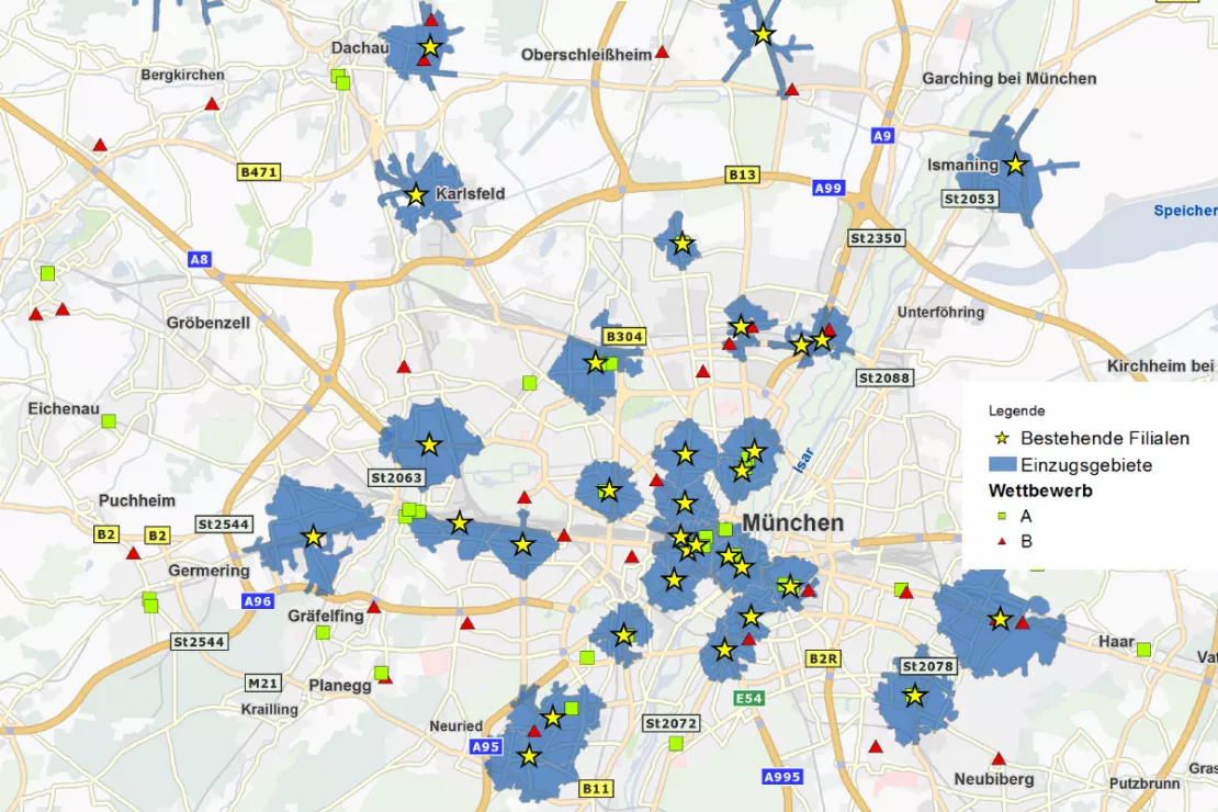
Geographic information, such as the location and density of the competition in the catchment area of a branch location, are essential for successful branch network optimization.
Optimizing the Branch Network with Geomarketing: How It Works
The restructuring and optimization of a branch network with geomarketing takes place in four steps. The first step is to examine the current branch network by determining a scoring value for each existing location. This is derived from the key figures of the environment (number of customers, inhabitants, competitive situation, purchasing power, etc.).
The second step is to perform a simulation analysis. In the third step an overall score is determined to rank the existing and simulated sites. In the fourth and final step, a recommendation is made or the decision is made as to which locations should remain, be closed, relocated or opened.
The goal of optimization is usually to achieve the highest possible degree of coverage with as few branches as possible. At the same time it aims to ensure that the distance between the branch and customer is as small as possible. This means: An ideal network of branches has as few locations as possible distributed in the area so that the largest possible proportion of the desired target group can visit the branches without having to travel long distances.
The Four Steps of Branch Network Restructuring and Optimization at a Glance
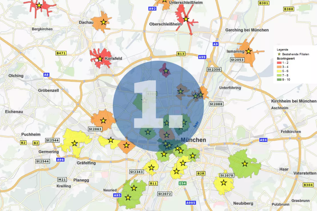
Evaluation of the Actual State of the Branch Network
The existing branch network can be analyzed and evaluated. Based on the market figures, such as distance to the competition, number of inhabitants, purchasing power, number of customers, etc., each branch can be evaluated. The scoring shows which branch locations perform well and which perform poorly in terms of the location environment and potential.
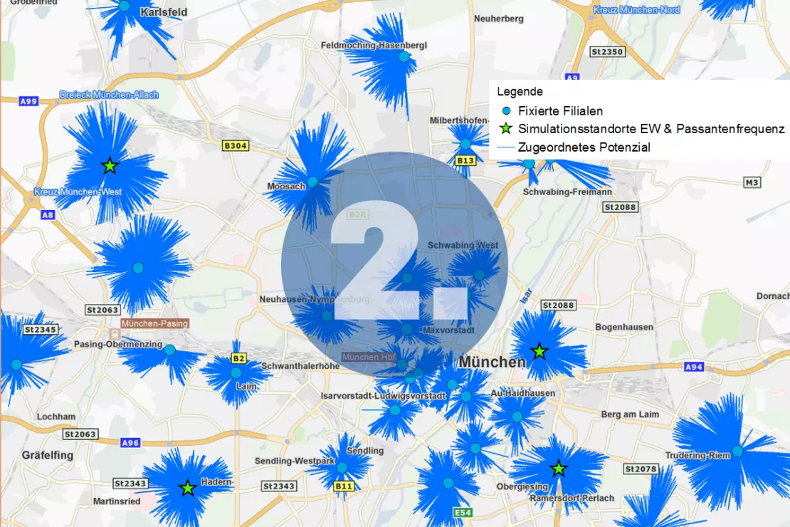
Simulation of Branch Networks
Using location-allocation analysis, it is possible to simulate how the degree of supply and potential turnover change when you supplement, close or relocate certain branches. Promising locations can be found and the interaction between existing branches can be evaluated.
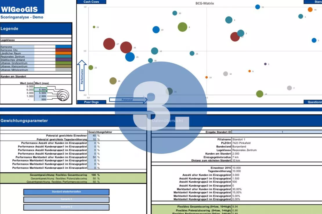
Total Scoring of Existing and Simulated Branches
The different branch network scenarios determined in step 2 are compared with each other. To do so, performance (e.g. sales, market share) is compared to potential. The final supply analysis shows which scenario offers the highest possible coverage with as few branches as possible.
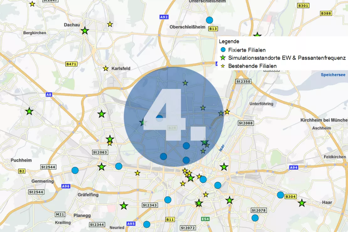
Optimized Branch Network
On the basis of the analyses, a recommendation is made on which locations branches should be closed, relocated, merged or opened. The result is a new, ideal branch network
Branch Network Reduction With the Help of Geomarketing - Alexander Wölfel and Holger Schurr in an Interview
Consolidation and reorientation have been affecting the banking and other sectors for several years. In the public, the discussion is always about the reduction of the branch network by closing and merging branches. In an interview, the two geoanalytics experts from WIGeoGIS, Alexander Wölfel and Holger Schurr, talk about how to reduce a branch network in a way that minimizes the effect on the customers and the company.
Optimizing a Branch Network: A Practical Example
WIGeoGIS has already implemented branch network optimizations for many companies. Based on an anonymous example, we will show you the way to the perfect branch network.
The Study Area
- Munich Metropolitan Region
- 34 existing locations
- Location classification subdivided into urban, suburban and rural locations with adaptation of the catchment area size in meters or minutes
Aim of the Study
The aim of the research contract was to reduce the branch network and at the same time to achieve a higher degree of coverage among customers and residents.
Simulation Scenarios
The study simulated four scenarios to optimize the branch network. The scenarios were designed in close consultation with the customer.
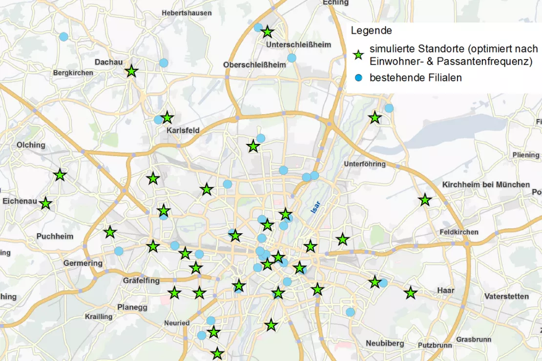
Scenario 1: Greenfield Analysis Population & Foot Traffic
Assumptions:
- No existing branches
- Simulation of 34 locations
Goal: Find locations in areas with high population and foot traffic
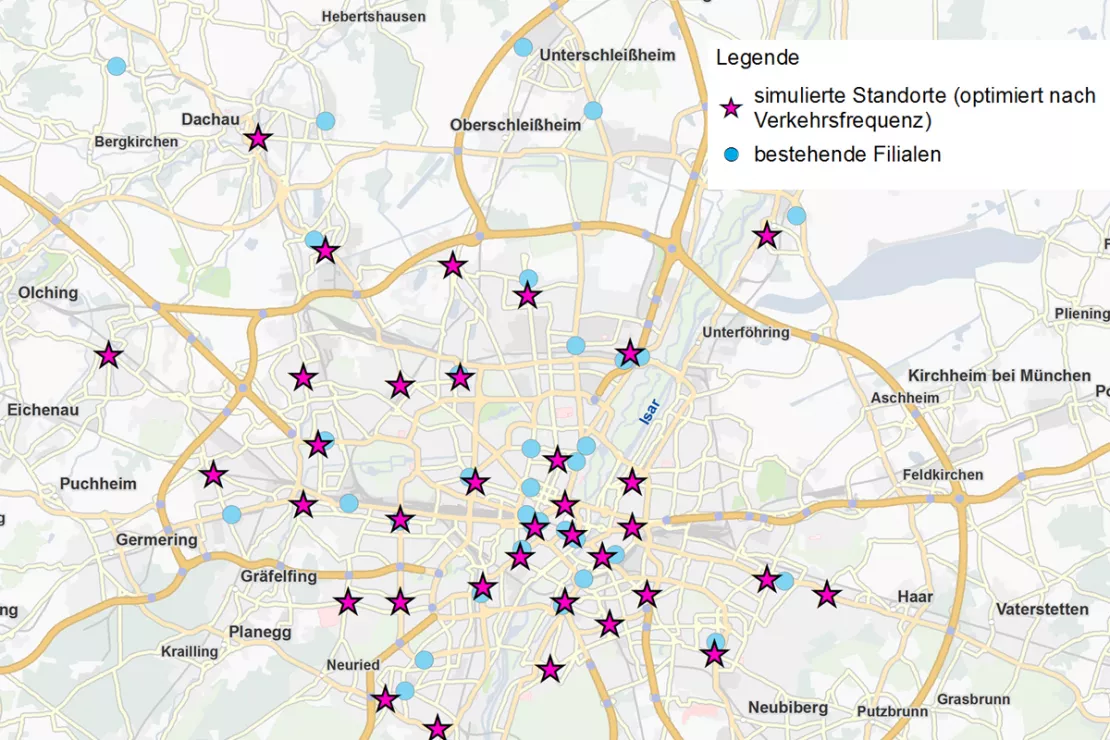
Scenario 2: Greenfield Analysis with Car Density
Assumptions:
- No existing branches
- Simulation of 34 locations
Goal: Find locations in areas with high passenger car traffic, in other words, on sections of the road where many cars pass by
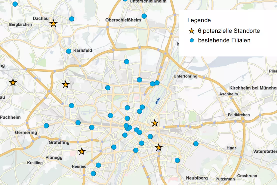
Scenario 3: Expansion by 6 Locations
Assumptions:
- 34 existing branch locations are retained
- Simulation of 6 new branch locations
Goal: Find new locations in areas with high population and foot traffic
Scenario 4: Closure of Branches
Assumptions:
- Top 15 locations with the highest turnover remain
- 4 existing locations were closed
- Simulation of 15 new branch locations
Goal: Find locations in areas with high population and foot traffic. Overall, the branch network was reduced by 4 locations.
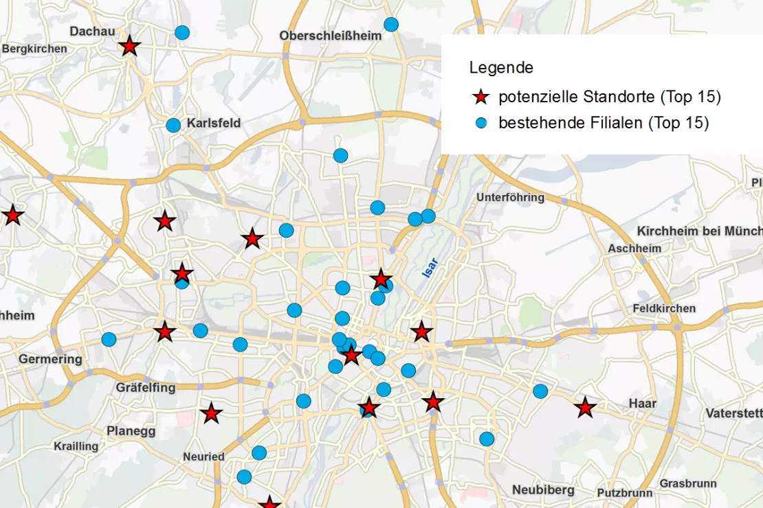
The Result
In the final overview of the existing and simulated locations as well as the supply analysis, it was found that:
- 15 existing locations should be retained and
- 15 new locations should be opened.
- Despite the reduction by 4 locations,
- the degree of coverage of the inhabitants will be increased by 25%!
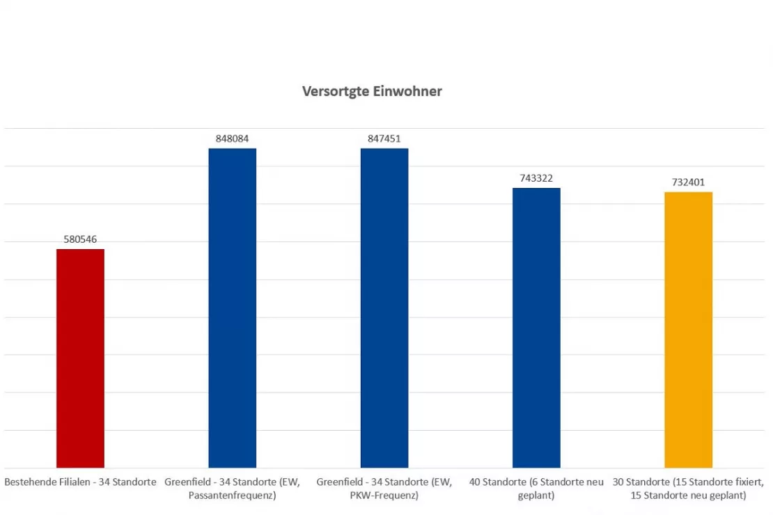
The branch network optimized by the geomarketing analysis achieved a higher degree of coverage with fewer locations compared to the old network.
JYSK is using geomarketing solutions
In order to grow, customers must be won away from the competition. This is only possible through a perfect location selection.

Unicredit Bank Austria: Geomarketing optimises sales structures
Using WIGeoGIS geomarketing software, UniCredit Bank Austria is optimising its sales structures based on physical branches.

ANWR GROUP uses WIGeoLocation
The trade cooperation ANWR GROUP generates location analyses for the specialist trade using WIGeoLocation.
WIGeoLocation: WebGIS software for location analysis
WIGeoLocation is the modern WebGIS software for location analysis. Your location report in just 3 minutes.
Optimize Branch Networks: Request a free initial consultation
- FREE initial consultation on branch network optimization
- Non-binding, without further obligations
- By telephone or video call
Do you want to optimize your branch networks? I will gladly support you. Please contact me!

