
GEOmarkets: Detailed Market and Geospatial Data for Germany
More than 600 data variables for precise market, customer, and site analysis. Comprehensive nationwide coverage, GDPR-compliant, and regularly updated.
GEOmarkets: Demographic Data and Microgeography for Germany
WIGeoGIS partner panadress marketing intelligence supplements this data with official data for 22.5 million buildings with information accurate down to the house number. This combination makes GEOmarkets a very precise and reliable basis for planning.
The data comes from various sources such as public directory data, high-quality anonymized address sources, surveys, the analysis of aerial photographs and official statistics. While microgeographic information was originally collected at the home level, official data is available at the municipal, district or state level. The data is merged using mathematical methods to create very valid, "officially calibrated" and scientifically validated data sets.
All data is anonymous and compliant with data protection laws making it impossible to draw conclusions about any individuals.
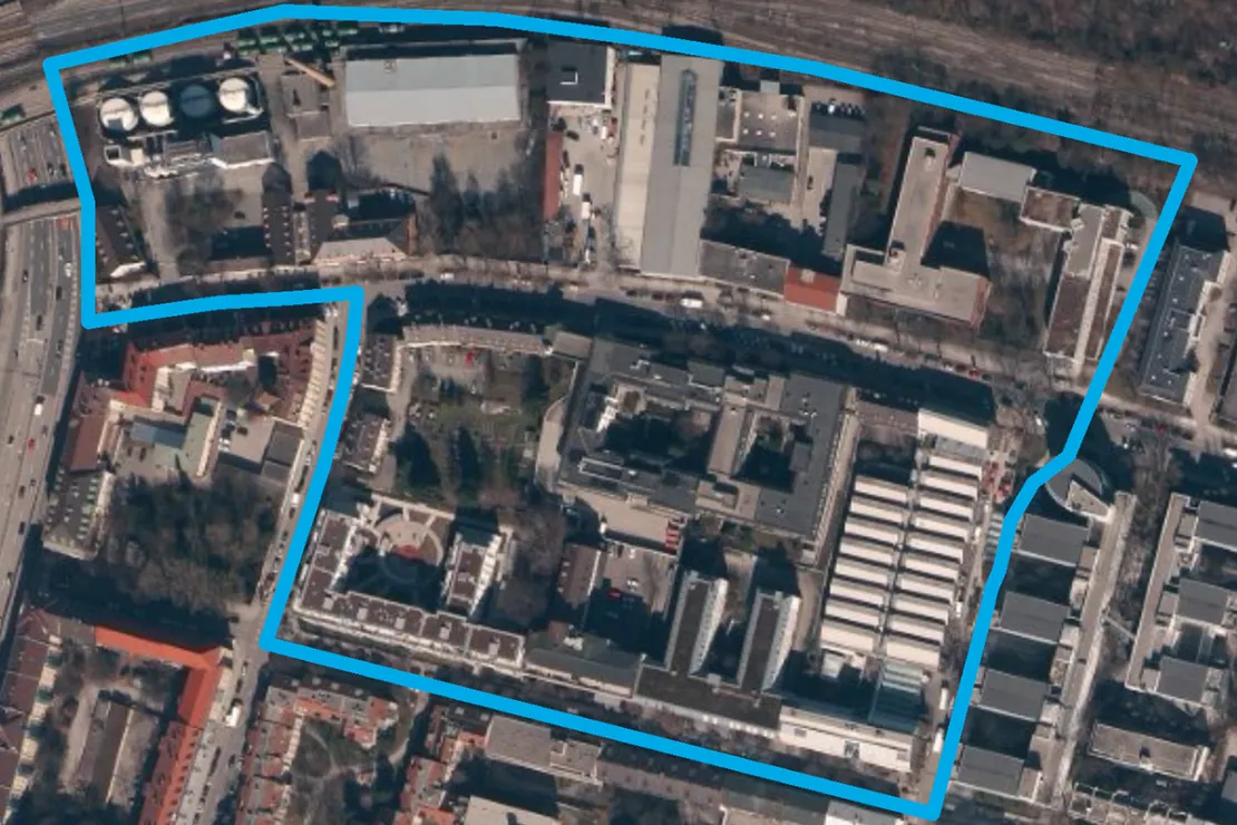
What are GEOmarkets?
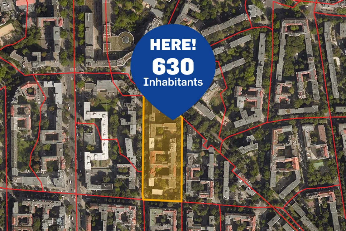
GEOmarkets are Germany’s micro-geographic market areas. Germany is divided into approximately 160,000 GEOmarkets, each comprising an average of 300 households. Their boundaries follow street networks and natural boundaries such as rivers and railway lines.
GEOmarkets:
- are based on real-world human behavior, such as shopping and mobility patterns,
- align with municipal and postal code boundaries,
- are updated annually.
GEOmarkets are suitable for all types of market analyses.
Over 600 different variables
From A like age group to generation Z.
Available at the following levels:
- Geomarkets (average 520 inhabitants) or larger
- Municipalities (average 10,000 inhabitants)
- ZIP Codes (average 7,400 inhabitants)
We will help you find what is right for you!
Demographics
- Single
- “Midst of life” 25 to 44 years
- Purchasing power for toys average
- Self-employed/freelance
- Average relocation activity
- 3-Person Household
- Commuter
- And much more
Consumers, Consumption, Automotive
- “No advertising” household
- Well-insured
- Willing to change service providers (electricity/gas)
- Affluent in the green belt
- Baby boomer
- Best Ager
- Vehicle age 10 years and older
- Drives a company car
- And much more
Building
- One- or two-family house
- Apartment building with 11 to 20 households
- Very good residential area
- No garden
- Building age 1961-1980
- Central location
- Mixed use
- And much more
Test GEOmarkets with more than 600 different variables for Free!
Geomarketing: Save Costs through Secondary Research
Primary research is related to market data when data is collected directly, e.g. in opinion polls, customer surveys, etc. Such market research instruments are usually expensive. In secondary research, it is often possible to gain the same information at a fraction of the cost through clever analytics: High-quality data in combination with the right attributes provide very precise answers in order to localize a defined target group regionally.
Renate Dumberger, Senior Manager WIGeoGIS, provides an example: “By combining age group, family structure and purchasing power based on consumer products and purchasing motive, one can see where the most singles from 20 to 39 years with a high purchasing power for womens clothing and a preference for branded products can be found in a region.”
GEOmarkets Germany: Test now free of charge and without obligation!
- Test data* on demographics, purchasing power or other characteristics
- Non-binding, free test
- Receive test data* as Excel or shape file
I will gladly support you, also by telephone.

* Information about the free test data: Selected test data for Germany is available for districts in Munich and the surrounding areas. The products of WIGeoGIS are intended for companies and are not suitable for private use. If you need a one-time market analysis, we will gladly make you a service offer.
FAQ
-
What are the advantages of target group analysis with GEOmarkets?
For companies, it helps you to avoid wastage and save printing and distribution costs for direct marketing campaigns. For retail stores or banks, it helps you to make better location decisions by allowing you to calculate catchment areas and target groups more precisely. Companies can also optimize their direct sales. For example, areas with the highest purchasing power can be identified.
-
Does WIGeoGIS also provide key figures on population development?
Yes! In addition to key figures on population development that compare the current population with a previous time, information is also often available for population projections, which for example is important for branch network planning.
-
Does GEOmarkets data comply with the GDPR
As all of the data providers in our partner pool, panadress offers data, which comply 100 % with the GDPR. Demographic data is aggregated data that does not allow conclusions to be drawn about individuals. Therefore, it is not considered as personal data within the meaning of the EU General Data Protection Regulation (GDPR). Data providers are subject to the strict rules of the GDPR and may not deliver data that allows conclusions to be drawn about individuals.
-
What makes GEOmarkets special?
- A GEOmarket contains on average 300 households
- There is comprehensive information on all 22.5 million inhabited buildings in Germany
- More than 600 variables are available
- The areas are updated annually, with Germany currently consisting of around 160,000 GEOmarkets
- GEOmarkets run along streets and natural borders such as rivers and railway lines and are thus oriented towards human (e.g. shopping) behavior
- The data comes from various sources such as public directory data, high-quality anonymized address sources, surveys, the analysis of aerial photographs and official statistics
- All data is anonymous and compliant with data protection laws making it impossible to draw conclusions about any individuals
Request your test access to GEOmarkets today for free with no obligation.