
Distance matrix: Calculate distances between any number of addresses
Get travel time and distance tables: quickly, by transport type, and in your preferred format
Get optimized routes between multiple start and destination addresses. Receive a distance matrix with precise information on travel time and distance, displayed as a table tailored to your specific requirements.
What is a distance matrix and what do companies use distance tables for?
A distance matrix, also called a distance table, shows how far apart locations or addresses are, or how long it takes to travel between them. Instead of measuring distances individually, we calculate every combination for you in one step. You receive a table with distances in kilometers and/or travel time based on your desired mode of transport (walking, cycling, car, public transport, truck, ship, plane, etc.).
Typical applications for distance tables include supply chain optimization, travel cost calculation, and distance analysis to customers, suppliers, and subcontractors.
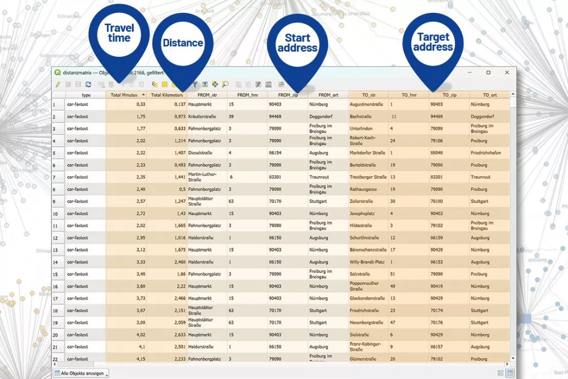
A distance matrix lists all the distances/travel times between addresses in a table. Companies and organizations can use this information in various business processes.
Questions about the distance matrix? Let's figure out your requirements together.

Request a Distance Matrix by Phone
Do you urgently need a distance matrix and would like to request one right away?
Call us directly at +49 89 321998 46 and have the following information ready:
- What data are you providing us, and how much?
- Do you need the distances in kilometers and/or time, and for which mode of transportation (car, truck, bicycle, public transit, etc.)?
- In what data format should we deliver the distance matrix?
Why do companies need a distance matrix?
A distance matrix is the right solution whenever a company needs to calculate multiple distances at once instead of a single route. The data from the distance table is subsequently structured and used for planning, cost accounting, or other business processes.
Examples of When a Distance Table Is Needed
You want to...
- Calculate distances to your customers.
- Calculate distances to your suppliers.
- Calculate distances to your subcontractors.
- Calculate distances for your shipments.
- Calculate travel or transport costs.
- Improve the service to your customers.
- Plan sales representative territories more realistically.
Application Areas of Distance Matrices
A distance matrix is a table showing the exact distances or travel times between all nodes, such as sales locations, customers, logistics centers, etc. This provides the basis for efficient planning of sales territories, sales representative routes, and supply chain networks, and helps to solve the following challenges:
- Territory structuring: Balancing sales territories based on actual travel time and the mode of transport used – for example, food delivery by bicycle, pharmaceutical sales representatives by car, and construction materials delivered by truck – to ensure a fair workload distribution.
- Location planning: Determining the ideal location for new warehouses, distribution centers, or branches to maximize accessibility.
- Capacity planning: Efficient allocation of customers to specific sales hubs.
I'd like to have WIGeoGIS generate a distance matrix for me!
Distance Matrix According to Your Individual Requirements
Every company has its own requirements. This also applies to calculating distances and designing a distance matrix.
WIGeoGIS calculates your distances exactly as you need them. We provide you with the actual, drivable roads and routes, not the distances as the crow flies.
Distance, Travel Time, or Both
Depending on the use case, we deliver your matrix by distance (kilometers) or time (minutes).
You can request the shortest route, the fastest route, or all the options in a table.
Modes of Transport
We create distance matrices for all modes of transport, including public transport, ship and flight routes, bicycles, e-bikes, and scooters.
- Car: standard for sales, delivery and travel expense accounting
- Truck: including vehicle-specific routing parameters
- Public transport: ideal for location planning and commuter routes
- Bicycle & E-Bike: for urban logistics and last-mile delivery
- On foot: e.g. for access to essential local services or healthcare
- Airplane: for international location and supply chain analyses
- Ship: for global supply chains and maritime logistics
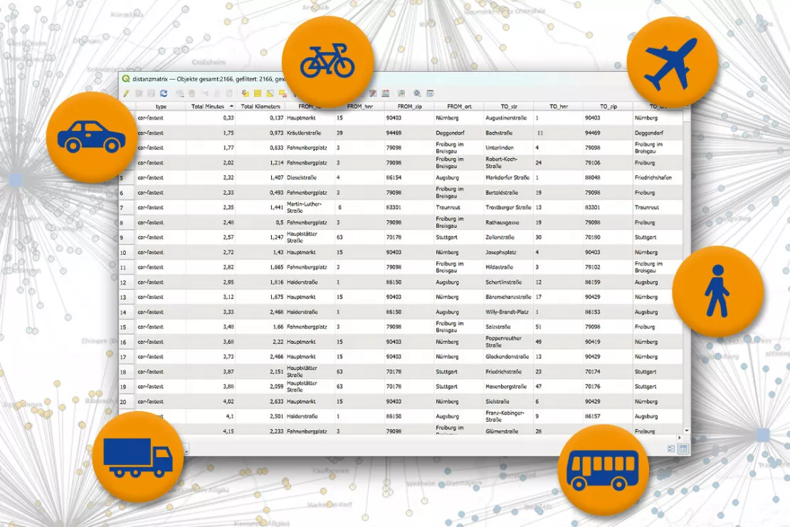
Global, geographic coverage across national borders
We calculate distances and distance matrices worldwide, across national borders. All we need for this is a spatial reference.
Examples:
- Coordinate to coordinate
- Address to address
- City names
- ZIP Code areas
- Other spatial reference
- Any combination of the above
Flexible Output Formats
Tell Us What You Need! We provide the finished matrix in the format of your choice, e.g.:
- Excel
- CSV
- JSON
- Text file
If you regularly need to calculate large numbers of distances, we recommend a REST API for direct integration into your systems.
What values should your distance matrix contain? We are happy to help you determine the best solution in a free initial consultation with absolutely no obligation.
How to Order a Distance Matrix: Simply Follow These Steps
1. You tell us what you need (via the contact form or by phone):
- Number/Extent of the distances
- Table with kilometers and/or travel time
- Desired means of transport, just one or several?
- How should the results table be structured?
- In which format (Excel, CSV, txt, JSON) should we send the distance matrix?
- What data are you providing us with (e.g., coordinates, addresses, ZIP Codes, other spatial references)?
2. We will prepare an individual non-binding offer for you.
3. Depending on the scope, we will create your distance matrix within 3 to 5 days.
4. We will email your distance matrix to you in the requested format.
Request your distance matrix right away
- Please call me or send me an email with your requirements.
- We'll deliver your individual distance matrices in just a few days.*

* The products of WIGeoGIS are intended for companies and are not suitable for private use. If you need a one-time market analysis, we will gladly make you a service offer.
FAQ
-
Where does the routing data come from and is it up-to-date?
We obtain our routing data from a variety of the best sources available. To give some examples: Our data providers include TomTom and OpenStreetMap. The data is constantly updated.
-
What happens with my addresses and customer data? Is the data processed in compliance with the GDPR?
Yes, any data you provide us is processed in compliance with the GDPR. This also includes the automatic deletion of data after your order is completed. If you would like to commission us to archive your data, this must be part of the order and stipulated in the contract.
-
In what format should my source data be provided?
You can send us your source data in any common data format: xlsx, txt, csv. The data is usually provided as a table.
-
Can I see a sample or test matrix in advance?
Yes, please contact us using the contact form on this page.
-
I use WIGeoWeb or QGIS. Can they be used to create a distance matrix?
Yes, that is possible. First we need to determine which parameters you want to calculate in your matrix (which country, distance or time, vehicle, etc.).