Artificial Intelligence and GIS - An Expert Interview
WIGeoGIS has been researching and developing possible applications for artificial intelligence in geographic information systems (GIS) for years. This brings advantages in geomarketing and perfectly complements traditional GIS methods.
Interview with WIGeoGIS Experts on Artificial Intelligence
WIGeoGIS has been researching artificial intelligence (AI) in geomarketing for several years and has launched the first AI-based product, WIGeo Location Atlas.
In an interview, WIGeoGIS experts Kai Barenscher and Janek Schönwetter report on the current and future areas of application for artificial intelligence in geomarketing, such as image analysis and geocoding, explain where there are still limits and challenges of the technology and when and why traditional geomarketing methods are still useful.
Everything About Artificial Intelligence in Geomarketing
- How long has WIGeoGIS been working with artificial intelligence?
- Which WIGeoGIS products already contain artificial intelligence in the narrower sense?
- Has artificial intelligence made traditional geomarketing methods obsolete?
- What are the advantages of using artificial intelligence in geomarketing?
- What are the limits, hurdles and challenges of artificial intelligence in geomarketing?
- Has artificial intelligence played a role in any other WIGeoGIS research projects?
- Where have you encountered the limits of artificial intelligence in your projects?
- What role do data privacy and data security play in the use of artificial intelligence in geomarketing?
- How do you see the future of artificial intelligence in geomarketing?
How long has WIGeoGIS been working with artificial intelligence?
Janek Schönwetter: It comes down to the question of how we define artificial intelligence. Due to the hype surrounding chatbots like ChatGPT, artificial intelligence is currently being equated with neural networks and deep learning. However, artificial intelligence is fundamentally about developing intelligent machines. These include a variety of algorithms, for example logical systems, clustering and decision trees. Deep learning is a technique for implementing machine learning. Today, almost every piece of software uses machine learning or artificial intelligence.
Kai Barenscher: As part of the WIGeoSocialData project, a research collaboration with the Department of Software Technology at Delft University of Technology, street image data was used for the first time to identify and categorize points of interest (POI), such as shops, that were then extracted for use in GIS. Through this two-stage process, the artificial intelligence (AI) was first able to identify a shop within a street scene. By converting the display window texts into machine-readable information, it was possible in a second step to determine a category from the POI. In the background, the information was integrated into pre-trained text models allowing the AI to determine for example that a POI is a beauty salon based on the terms hair, fingernails and make-up. In a broader sense, however, we have been working with AI for some time: Our software has been automatically performing simulation calculations such as sales forecasts since 2005, using mathematical procedures in the background.
Which WIGeoGIS products already contain artificial intelligence in the narrower sense?
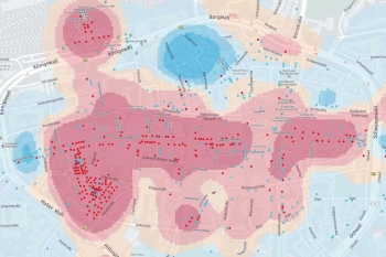
Kai Barenscher: Artificial intelligence is already integrated in WIGeo Location Atlas. The data product analyzes any location in Germany, Austria and Switzerland with regard to the most important location factors for the retail sector, such as supply density, branch density or quality and price level. The result is displayed in the form of a heat map or enriched points of interest (POI) similar to a weather map. This means that those areas are shown on the map which best meet the location factors that are important for a company. This works thanks to machine learning. Specifically, millions of points of interest (POI) were trained in advance by WIGeoGIS, for example by assigning certain company names and industry classifications to previously defined categories of the WIGeo Location Atlas.
Identify your market potential thanks to artificial intelligence? We'll show you how!
Has artificial intelligence made traditional geomarketing methods obsolete?
Janek Schönwetter: Artificial intelligence is not always the better choice in geomarketing. An example: Instead of programming an AI that uses street image data to identify what type of business is at a location, this data could also be collected through a classic on-site inspection. This can certainly be more useful if, for example, the street images are outdated. Artificial intelligence simply offers additional possibilities. Whether it is the better choice depends on the specific task.
Kai Barenscher: There is rarely an advantage without a disadvantage, even with artificial intelligence. Some of these systems require extensive hardware requirements and computing power, so lean databases are no longer sufficient. So, you always have to weigh the cost-benefit ratio.

Artificial intelligence is not always the better choice in geomarketing. Artificial intelligence simply offers additional possibilities. Whether it is the better choice depends on the specific task.
Janek Schönwetter, Software Developer, WIGeoGIS Munich
What are the advantages of using artificial intelligence in geomarketing?
Kai Barenscher: Essentially, there are currently four possible areas of application that are relevant in geomarketing: image analysis, text processing in the area of geocoding and address searches, the processing of geographical data and classic location analytics. We are currently working intensively with the latter as part of a research project. In the area of location analytics, we cannot say anything specific about the potential benefits of AI because we are still researching it. However, there is a clear trend that AI is particularly useful and helpful with unstructured data. If I have addresses with a location, street name and house number, I do not need machine learning because this is unique information that can be compared more efficiently and quickly using classic SQL techniques. However, if restaurants for example are described by hundreds of users and an AI is supposed to calculate ratings based on those descriptions, that is unstructured data. Then I can cluster these texts in the background using machine learning and make a basic statement at the end.
You want to elevate your location analyses to the next level - we will inform you about the WIGeo Location Atlas!
What are the limits, hurdles and challenges of artificial intelligence in geomarketing?
Janek Schönwetter: Machine learning models require a very large amount of training data to be practical and powerful. Another aspect is data quality. If data are based on erroneous measurements or information, this will affect the quality of the learned model. There are also statistical outliers that can be a problem. In addition, the training data must be representative and relevant to my question. There is also the question of whether the data has too many irrelevant features to train the AI correctly. For example, the names of passengers will not help to predict flight cancellations. For this, I need weather data, which can also include outliers such as volcanic eruptions. Machine learning models are very complex. Everything has to work together, from the data quality and relevance, all the way to the amount of training data.
AI projects always require a "human in the loop", i.e. a human check. This was also very important for WIGeo Location Atlas, for example, when allocating location factors.
Kai Barenscher, Senior Manager, WIGeoGIS Vienna

Has artificial intelligence played a role in any other WIGeoGIS research projects?
Kai Barenscher: Yes, in the research project GeocoderML, which works with machine learning and pre-trained language models. The aim was to improve the search for addresses and POIs. Often, people do not search for specific addresses, but rather the search entries include vague spatial information and search requirements. With the search "Beautiful view of Lake Starnberg" I am probably looking for a restaurant or cafe. With "I'm in Klagenfurt and my vacuum cleaner is broken" I am probably looking for a home appliance store. The model was trained in such a way that it recognizes what the search input is about through semantic mapping and suggests, for example, restaurants with terraces on Lake Starnberg or home appliance stores in Klagenfurt as results. Another research project we are currently working on is LocAl.ly. We are trying to train artificial intelligence so that it can predict how well a location will perform, for example how much turnover it is likely to generate.
Where have you encountered the limits of artificial intelligence in your projects?
Kai Barenscher: For example, in the WIGeoSocialData project, if street images were blurry or taken from an unfavorable angle, the AI had difficulties recognize the writing. In the research project GeocoderML, a semantic search for "fries with ketchup", also returned an appliance store called "Heinz", presumably because there is also a ketchup brand with the same name. That is why AI projects always need a "human in the loop", i.e. a human check. This was also important, for example, when assigning categories in WIGeo Location Atlas.
Curious? We are happy to provide consultation on the WIGeo Location Atlas!
What role do data privacy and data security play in the use of artificial intelligence in geomarketing?
Janek Schönwetter: This depends on the application. We always ask ourselves how we can use the source data while still ensuring strong data privacy practices. Basically, we offer solutions for companies that analyze their customer and company data in order to generate added value from it. This data is not passed on to any third parties, however, if our customer chooses one of our hosting solutions, it is processed in our data center. If our customer chooses one of our local installation solutions, the data is stored on their company servers
Kai Barenscher: The more sensitive the data is in terms of data privacy, the more carefully we and our customers have to handle it. One security measure is to run the data and processes on our computers rather than in the cloud.
How do you see the future of artificial intelligence in geomarketing?
Kai Barenscher: Ideally, artificial intelligence should simplify usability for our customers without them even having to think about it. Maybe in the future they will just tell WIGeoWeb, "I want to open four new branches", and in the background the machine learning model will calculate the locations with the most potential. In the foreground, maybe the answer is given by a chatbot.
Janek Schönwetter: Artificial intelligence will be an extension to existing processes and offers great potential. However, it always strongly depends on the application as to whether AI in the background is actually necessary for our customers or whether proven geomarketing methods are preferable.
Janek and Kai, thank you very much for the interview.
Further information on the WIGeo Location Atlas and simulation calculations for your location analysis

Location Analysis with Artificial Intelligence
Three years of development went into WIGeo Location Atlas, taking location analysis to a new level. With this new product, you can find the most attractive areas for your location more quickly than ever before.

WIGeo Location Data - High-Quality POI Data for DACH
Discover the power of WIGeo Location Data – high-quality POI and location factors for retail, gastronomy, and service industries in Germany, Austria, and Switzerland. Make smarter location decisions.

Location Analysis
WIGeoGIS supports your location analysis with extensive consulting know-how and geomarketing software. This allows you to efficiently assess your branch and retail networks.
Identifying market potential thanks to AI: Request a free initial consultation
- FREE initial consultation on market analysis thanks to artificial intelligence
- Non-binding, without further obligations
- By telephone or video call
Would you like to know how your company can analyze markets efficiently thanks to AI? I will gladly support you. Please contact me!

